
Please enable JavaScript to use the website of the Tokyo Metropolitan Government.
Main content starts here.
August 4. 2020
Bureau of Construction
Japan Meteorological Agency Forecast Department
Tokyo Regional Headquarters, JMA
Flood forecasts for the Myoshoji River available from August 6
The Tokyo Metropolitan Government (TMG) and the Japan Meteorological Agency (JMA) will begin to provide flood forecasts for the Myoshoji River, as already provided for the Kanda, Arakawa, Shin-Shiba, Meguro, Shibuya, Furukawa, Nogawa, and Senkawa Rivers.
The Myoshoji River was previously classified as a water level notification river, with the Tokyo Metropolitan Government providing information about the risk of flooding to be used in autonomous decisions regarding evacuation. It will now be classified as a flood forecast river*, with flood danger information being provided in conjunction with the JMA.
*Flood forecast rivers have disaster warning information released when they are considered at risk of flooding due to heavy rain.
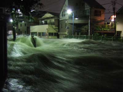
<Image of the Myoshoji River flooding (September 4, 2005)>
Near Kitahara Bridge (provided by Nakano City)
1 Start of operations
From Thursday, August 6, 2020
2 Timing of announcements
Using JMA rainfall prediction data from up to one hour in advance, the TMG will predict changes to the river’s water level, and if there is thought to be a risk of flooding, the TMG and JMA will jointly release flood danger information*.
*Flood risk information refers to information corresponding to alert level 4, with evacuation from areas at risk being compulsory. Regular flood forecasts assess the risk of flooding, with announcements progressively ranging from flood cautions, flood alert information, flood danger information to flood inundation information. Because water levels in flood forecast rivers in Tokyo can rise extraordinarily quickly, only flood danger information is announced.
3 Information for Tokyo residents
In addition to receiving disaster information via radio or E-mail from your local authority, you can find information from media sources such as public radio and television. Furthermore, flood information can be verified on the JMA and TMG websites.
- Tokyo Metropolitan Flood Control Integrated Information System website: 日本語 / English / 中文 / 한국어
- Japan Meteorological Agency webpage on flood forecast rivers( External link ) (in Japanese)
- Japan Meteorological Agency Real Time Flood Risk Map( External link ) (available in English)
4 What to do if a flood forecast is announced
Because the Myoshoji Rivers’s water level can rise extraordinarily quickly during heavy rain, it is likely that flooding will occur shortly after a flood forecast is announced. If a flood forecast is announced, please act quickly by moving from areas along the river that are likely to be flooded, such as underground areas, and evacuate to the higher floors of buildings.
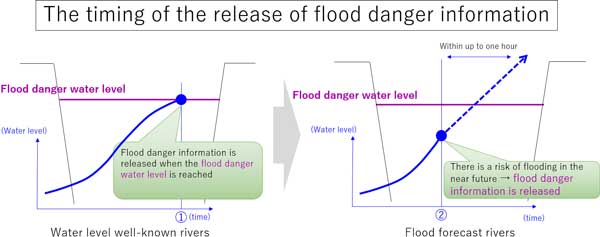
The difference between water level notification rivers and flood forecast rivers
Water level notification rivers have flood danger information issued when their water level reaches a pre-determined flood danger level. Flood forecast rivers have flood danger information announced if it is determined that flooding is likely in up to one hour due to a rise in water levels, based on predicted water levels.
It is now possible to forecast flooding by the Myoshoji River thanks to analysis of previously gathered data, the installation of stormwater ponds, and improvement in water level prediction techniques.
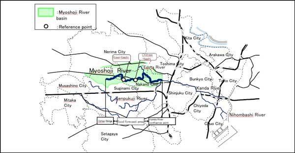
Location of the Myoshoji River
Please click here for the original Japanese press release.
| Inquiries (in Japanese only) |
| Disaster Prevention Section River Division Bureau of Construction Phone: 03-5320-5190 Office of Weather Disaster Prevention Forecast Division Forecast Department Japan Meteorological Agency Phone: 03-3212-8341 |